

Research:
Joplin, MO Tornado
Event Summary - 22 May 2011
- EF-5 tornado (200 mph+)
- 22 mile damage path, 38 minute duration (2234Z – 2312Z)
- 6 miles of EF-4+ damage, 1 mile wide at maximum
- Rapidly intensified from touchdown to peak intensity (4 minutes)
- Cell mergers occurred shortly before intensification
- High CAPE environment with shear increasing before tornado time
- CAPE > 4000 J kg-1 K-1, Effective SREH: 150 m2 s-2 => 300 m2 s-2

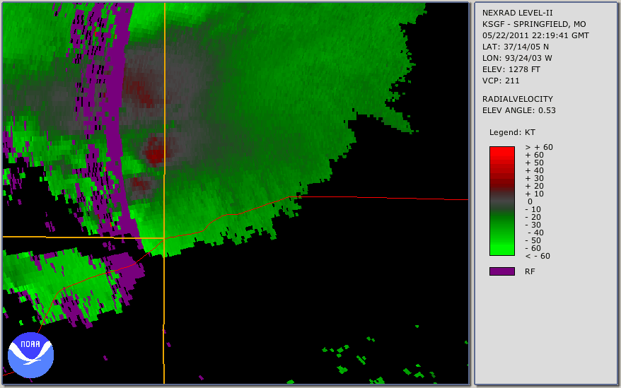
Image retrieved from
NWS Central Region Service Assessment.
Observed Radar Imagery - KSGF WSR-88D

Research Motivation
- NWS Service Assessment
- WFO Springfield noted that more deviant storm motions signaled localized low-level helicity was beyond values in analysis.
- Cell Mergers
- “…along with the recognition of a cell merger over southeast Kansas, led directly to the early warning of the Joplin tornado.”
- Rapid Intensification
- “Low-level rotational intensification and tornadogenesis occurred very rapidly with the Joplin tornado...”
- 534pm CDT touchdown to 538pm CDT EF-4 damage
- What effect did the cell mergers have on the intensification of the Joplin tornado?
Literature
- Lemon 1976
- “The overall effect of the cell merger is increased updraft velocity…bringing decreased surface pressure and increased surface convergence.”
- Lee et al 2006 (I,II)
- Occurrence of tornadogenesis in close proximity to time of cell mergers
Model Configuration - WRF-ARW v3.3.1

Ongoing Results - Real Data WRF Simulation
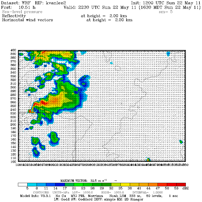 Simulated Reflectivity @ 2km AGL
Light Gray = 30 dBz Shading Dark Gray = 50 dbZ Shading
Black lines = pressure contour every 2 hPa
Wind Vectors placed every 5th grid point
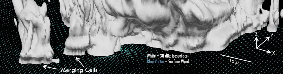
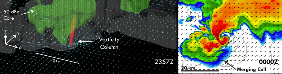
Cell Mergers - WRF Simulation
Discussion
- Preliminary results reveal at least a modest connection between DRCs and tornadogenesis
- In this simulation, DRCs exhibit a pulse-like behavior during merging process.
- Present before each intensification of low-level vortex
- Increased convergence along rear-flank gust front
- Caused by increased precipitation loading?
- Large amount of previous work regarding DRCs
- Rasmussen et al 2006 – Observations of DRCs during Vortex
- Kennedy et al 2007 – DRCs study using WSR-88D data
- Byko et al 2009 – DOWs and Idealized Simulations
- Markowski et al 2012 – DRC in Goshen, WY storm during Vortex2
- Noted rapid intensification preceded by DRC
Storm history - maximum surface vorticity and wind speed for entire simulation
The simulated vortex is evident in these two figures showing the trace of highest surface rotation and wind speed.
 |
 |
| Maximum vorticity | Maximum wind speed |
Current Direction
- Utilizing an analysis code to track changes in the local and environmental shear and thermodynamic profiles
- Performing Idealized WRF simulations to identify the affects of these changes on the storm intensity
- Identify the effects of different strengths and orientations
of storm mergers
Presentations and Publications
Van Leer, Kevin W., Brian F. Jewett and Robert B. Wilhelmson, 2012: Rapid Intensification, Storm Merging, and the Joplin Tornado. Conference notebook summary, Bulletin of the American Meteorological Society, Feb. 2013. source material / notebook PDF.
Van Leer, Kevin W., Brian F. Jewett and Robert B. Wilhelmson, 2012: Rapid Intensification Mechanisms Including the Role of Storm Mergers in the 22 May 2011 Joplin, MO Tornadic Storm. 26th Conference on Severe Local Storms. American Meteorological Society (AMS). Nashville, TN; link.
Van Leer, Kevin W., Brian F. Jewett and Robert B. Wilhelmson, 2012: Investigating Rapid Storm Intensification Mechanisms Including the Role of Storm Mergers in the 22 May 2011 Joplin, MO Tornadic Storm (P.79). 13th WRF Users' Workshop. National Center for Atmospheric Research (NCAR). Boulder, CO; link.